
 Science, technology and engineering are constantly advancing, so we took a few minutes to ask one of our resident engineers about some tech that seems like it is from the future: point clouds. If you’ve ever heard the term point cloud and wondered what it means, how do we come up with them, or what they might be used for, Brandon Cathcart, P.Eng., answers those questions and more in the interview!
1. What is a point cloud?
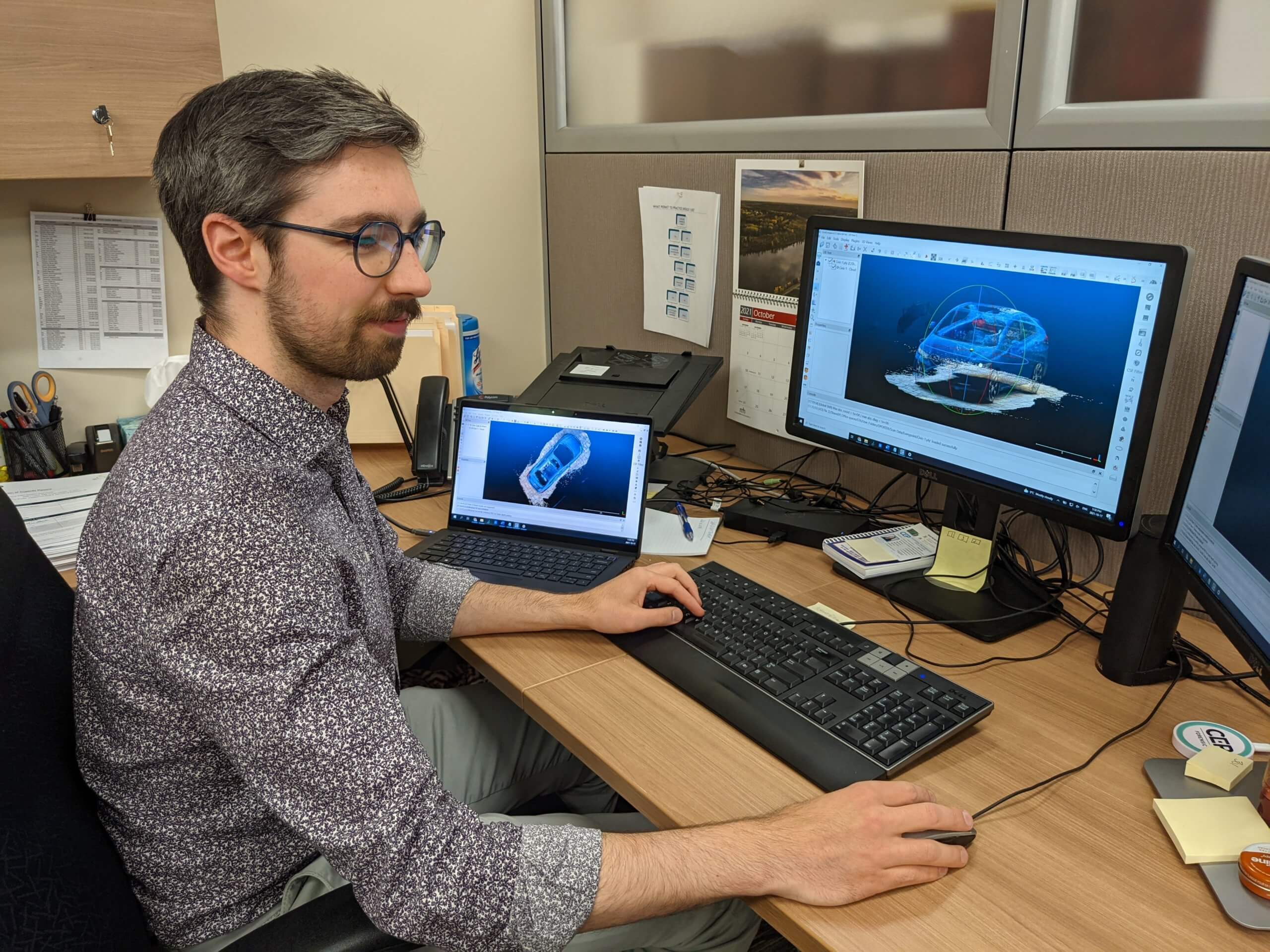
A point cloud is a data set of 3D points. While we’ve taken 3D points for a long time, you may have seen them in projects before, with point clouds, the density of points is much greater. Instead of 30-100 points, we can take thousands of points of an area, which vastly improves what we use and take from the information. Additionally, point clouds can now store colour information, so where before it was just points in space along an x/y/z access, now we can assign colours to that as well, which really helps to visualize the data.
2. How do you capture a point cloud?
Well, there are a few ways to do it: professional scanners are the tool of choice for point clouds. There are companies like Faro and Leica who are creating scanners that you place in a room or outside, and it will take a 3D scan of the environment or thing. You can put it in 2-3 places and capture an entire scene quite quickly that way. But there is also some software that takes photographs of an object or scene and uses that to recreate the scene in 3D. So, just by triangulating the camera placement, it can essentially take these 2D images and recreate the space in 3D.
3. Are the special cameras the only way to generate point clouds, or is there anything else that you can use?
In the last few years, there have been some iPhone apps developed, which allow almost anyone to capture this 3D data on their phone. So, if you’d like to, you can download them and try them out on things around your house. There are two that come to mind, first is Matterport, which is great for capturing an area or a room. I see it used in real estate sometimes, as well. Essentially, you do the same thing as the scanner would do, moving your phone in a 360 degree circle, and it captures photographs and points of the area, processing those to create a 3D visualization of the environment. The other one is EveryPoint, where it is essentially using the LIDAR on your phone, as well as photographs, to scan objects and scenes. It is pretty magnificent how far technology has come.
4. If all you need to do is download an app, can adjusters generate and share these?
In terms of capturing the data, there is no reason an adjuster cannot do this. Anyone can get the app on their phone. An engineer might have a different perspective on what to focus on, or what is important or not, though. That being said, it is important that this data get captured if it can be, so having an adjuster do it would be great. It is worth noting, however, with Matterport you can only have one space on their free account right now. So, unless you are going to pay for the monthly subscription, you can save one building at a time, which isn’t ideal if you have a large loss or more than one file. But, with Every Point, you can take as many captures as you want for free. However, unless you are trained in using that data, it can be more difficult to use, involving an engineer may be ideal.
5. How do point clouds realistically help an investigation?
There are two real ways that capturing 3D data can be useful: the first is visualizing the space, and the second is measurements after the fact.
For example, perhaps you have a few photographs of a scene, which give you an idea of what’s in the room. But, if you can instead hop into that space and look around, all of a sudden, you’re not just seeing a photo of this or a photo of that… You can see how everything is spaced, where everything is relative to each other, and it gives a bit more context. In terms of a fire scene, maybe you’re looking at a burn pattern over here, and seeing some wires over there, and that could help you determine what is victim vs. cause. In a property investigation, maybe you need to trace some piping. Rather than flipping through your photographs trying to make sure everything lines up, you’re just looking at this entire 3D image where you can see the piping throughout the room.
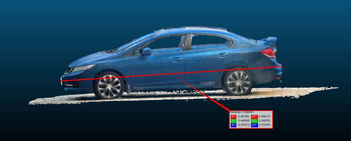
Since these are points in 3D space, you can take measurements from them after the fact. Say we want to see how big a room is, or the distance between this and that, basically, we can pull up this data set and find out the distances. Now, I will add in a caveat here; if you are using the professional scanners, you are looking at millimetre accuracy, which is excellent. But if you are using the iPhone apps, then its not going to be that accurate. You can usually get within an inch or two in a room, which is fine for general measurements and spatialization, but if you need an exact measurement, you need to use the professional scanners.